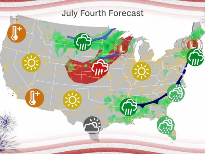
Severe storms and record heat pose serious risks for the Fourth of July holiday, so don't be surprised if the forecast forces a celebration backup plan.
While the record heat might be easing in the South, it's building elsewhere. And the storm threat isn't taking a holiday as it remains active through much of this week after recent deadly storms across the country.
Get your local forecast here
Here's what to plan for today, and on the Fourth of July, region by region:
Mid-Atlantic and Northeast: Severe storms will threaten millions
Today: The threat includes much of the mid-Atlantic with a Level 2 out of 5 slight risk of severe storms, including Washington, DC. Damaging winds and large hail will be the main threats during the afternoon and evening hours. Fourth of July: The overall threat takes a step down but extends into the Northeast and includes New York City. The biggest threat for storms will be during the afternoon and evening hours, and even though storms should be hit or miss, some could pack quite a punch, so fireworks could get disrupted.
Southeast: Heat indices climb as high as 110 degrees with storms possible
Some storms could be severe both today and on the Fourth of July during the afternoon and late evening hours, with damaging winds, large hail and an isolated tornado or two. Have a plan in place in case you need to seek shelter at a holiday celebration. Heat advisories are in effect from the North Florida coast to southern Virginia where temperatures will top out in the upper 90s. The heat index for these areas could reach a dangerous 110 degrees, so make sure to drink a lot of water and have a cool place to take breaks from the heat outdoors.
Midwest and Plains: Severe storms and the hottest temperatures of the year so far
The Midwest and Plains will also face a serious Level 2 out of 5 risk of severe weather for damaging winds and large hail today and on the Fourth of July. Today's storms will primarily be in the afternoon and evening hours, but tomorrow's storms will be more widespread. The hottest temperatures so far this year are expected today with heat indices reaching the mid to upper 90s for portions of the Midwest. Those temperatures will ease once the cold front passes through the area tomorrow.
The West: No storm threat, but dangerous heat
While the West will avoid the storm threat, millions won't be able to escape the heat. Triple digit temperatures will dominate across California's Central Valley and the Desert Southwest today. The heat index could reach 120 degrees in the Colorado River Valley and up to 125 degrees in Death Valley, California. The heat will ease tomorrow in the Southwest and build in the Pacific Northwest. Several records could be broken, as highs are forecast to reach the triple digits on Tuesday across portions of Oregon and Northern California.
Severe storms and excessive rainfall forecast for much of the week
Severe storms and torrential rain won't stop after the holiday. On Wednesday, the threat will cover roughly 90 million people. The main risk area will be across the Midwest and Southern Plains with a Level 2 out of 5 slight risk for for places like Chicago, Indianapolis, Denver, Kansas City, Missouri and Tulsa, Oklahoma.
The Storm Prediction Center is also highlighting an area in the Plains on Thursday to watch out for the threat for severe weather, but it's too early for the details. Make sure to check back here for any updates through the week.
Any of these storms will have the potential to produce torrential rainfall, so be prepared for flash flooding through the week.


